The NCC provides a free shuttle service six days a week from spring to fall. The shuttle will bring you to popular destinations near the parkways. Let the Park drive you.
Schedule
Six days a week (no service on Wednesday)
No reservations, limited seating: first come, first served
Disclaimer: If you miss the last shuttle, you are responsible for leaving Gatineau Park yourself. The following taxi company serves the park: Transit (819-779-2299).
May 17 to September 19, 2025: Shuttle service every 30 minutes
Saturdays, Sundays and Holidays
On weekends and Holidays*, the shuttle runs from downtown Ottawa-Gatineau and from the Chelsea Visitor Centre.
| First departure | Last departure | |
| Ottawa-Gatineau to the Visitor Centre | 9:10 am | 3:10 pm |
| Visitor Centre to Ottawa-Gatineau | 9:45 am | 4:45 pm |
Time for entire route is approximately 90 minutes.
* Holidays: May 19, June 24, June 30, July 1, August 4 and September 1, 2025
Mondays, Tuesdays, Thursdays and Fridays (except Holidays)
On weekdays, the shuttle only runs from the Visitor Centre to Pink Lake.
The shuttle enters and exits the parkways three times a day via the Visitor Centre. Otherwise, it roams the parkways between Pink Lake and Champlain Lookout.
| Departure times | |
| Visitor Centre to Pink Lake | Every 30 minutes between 9:30 am and 11 am |
| Pink Lake to Visitor Centre | Every 30 minutes between 10:30 am and 2 pm |
September 20 to October 26, 2025
The detailed schedule will be posted later.
Stops
You can board and disembark at any of the following stops when there is service. Click on the stop of your choice to learn more about the nearby services and attractions.
Pīndigen Park stop location
(Service on weekends only)
This stop connects with OC Transpo bus routes; Pimisi Station (O-Train) is 350 metres away.
Parking on nearby streets and at the Canadian War Museum ($).
Canadian Museum of History stop location
(Service on weekends only)
There is parking on nearby streets, at the museum, and at the Jacques-Cartier Park marina.
Montcalm stop location
(Service on weekends only)
This stop connects with STO bus routes and Rapibus.
Parking on nearby streets.

This stop is at the south entrance of the Park, at the edge of the forest, just steps away from the city. It’s a popular starting point for hiking and biking, especially on the 200-km paved, multi-use pathway that winds through the Capital.
South entrance (P3) stop location
(Service on weekends only)
What to do
- Discover Gatineau Park’s history, geography and ecosystems on the giant map in the rest area.
- Explore the Pioneers Trail. Interpretation panels highlight the history of settlers in the Outaouais region and the diversity of forests in Gatineau Park.
A little further
From the paved pathway, you can get to Lac-des-Fées Pathway, great for birding along the lakeshore. Trail 5, also called the Capital Pathway, leads to the Asticou Centre, Relais plein air, and beyond.

Pink Lake is an exceptional lake in Gatineau Park. It is a meromictic lake, which means that the water at the lake’s bottom and surface never mix. This phenomenon contributes to the lake’s turquoise colour. The lake was named after the Pink family, who settled here in 1826.
What to do
- Take in the panoramic view from the accessible lookout and read the interpretation panels.
- Go down the stairs to follow Pink Lake Trail around the lake and enjoy lovely views.
A little further
Although it is a long walk, you can access the Mackenzie King Estate via trails 35 and 15. The cottages that have been converted into museums, the historic ruins, and the gardens are worth the trip.

Mackenzie King Estate stop location
What to do
- Walk around the Kingswood and Moorside cottages.
- Stroll through the gardens.
- Discover the ruins.
- Learn about the site’s history from our interpretive guides and interactive exhibits.
A little further
The Lauriault and Waterfall trails, which run along a stream, will lead you to the Bridal Veil Falls and a stone lookout. Although it is a long walk, you can also access Pink Lake via trails 15 and 35.

Lauriault/Mulvihill stop location
What to do
- Discover Mulvihill Lake, with its aquatic wildlife, picnic area, and accessible lookout.
- Explore the Lauriault and Waterfall trails, which travel along a stream and will lead you to the Bridal Veil Falls and a stone lookout.
A little further
Mackenzie King Estate, with its magnificent historic ruins, is only 1 km from the stop, if you take the Lauriault Trail on the Mulvihill side. Extend your hike by visiting the cottage museums and admiring the gardens.

King Mountain stop location
What to do
- King Mountain Trail is a challenging loop featuring interpretive panels. Follow it counter-clockwise and stop to look out over the Eardley Escarpment. You will also pass by Canada’s first geodetic survey station.
A little further
Start your hike on King Mountain Trail going clockwise. Turn left onto Trail 37 and, after a short distance, you will cross Champlain Parkway. This will take you to the Wattsford Lookout, where you can take in a lovely view.

Champlain Lookout stop location
What to do
- Admire the view from the accessible lookout with its iconic wall.
- Go down the stairs to follow Champlain Trail and read the interpretive panels. The unique microclimate hosts many rare species.
A little further
Just a few kilometres away are day shelters and a lookout with a view over the city. Follow Trail 1 east to the Étienne Brûlé Lookout and Huron Shelter, or head west toward the Western Shelter.

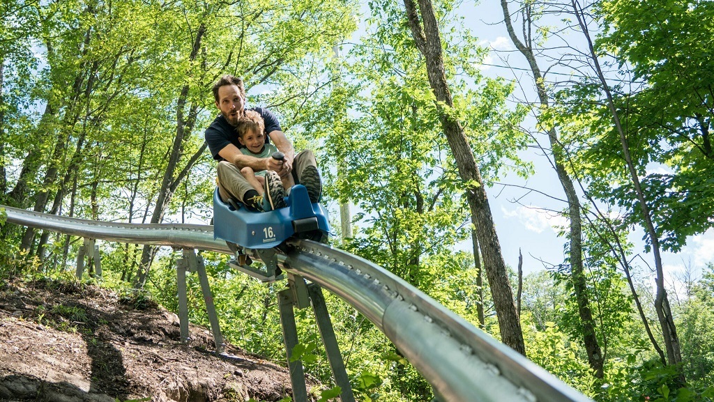
Camp Fortune stop location
What to do
- Enjoy hiking and mountain biking trails.
- Fly through the air on a zipline and test your balance and climbing skills at the aerial park.
- Try the Mountain Coaster, an exciting 1 km long monorail ride through the forest.
A little further
From Trail 4, starting beyond the aerial park, take Trail 1 to the Keogan Shelter or Wattsford Lookout on the other side of Camp Fortune. It is part of the Trans Canada Trail, which stretches across Canada.

Visitor Centre stop location
What to do
- Visit the interactive exhibit to learn about the Park’s history and ecosystems.
- Visit the boutique for Park-themed apparel, souvenirs and hiking essentials.
- Cross the small bridge to reach the Sugarbush Trail, one of four walking trails open year-round.
- Near the large grassy area, enjoy picnic tables or the Sugarbush Shelter in case of rain.
- Make your way towards P4 to enjoy a waterfall, picnic area and trail.
A little further
This stop is in the heart of the village of Old Chelsea. Cross Scott Road to discover charming shops and cafés. At the end of the road, you will find a small bridge spanning a beautiful waterfall and leading to a picnic area.


Accessibility
All shuttles are equipped with an access ramp and low floor. All stops are accessible to people with reduced mobility.
Discover Gatineau Park’s accessible infrastructure and activities, and learn more about what we do to improve access for people with reduced mobility.
Know before you go
- Safety: Engaging in outdoor activities involves certain risks. Plan a safe and enjoyable outing by following our safety tips.
- Cycling: The shuttles are equipped with bike racks; availability is first-come, first-served.
- In-line skating: In-line skates and roller skis are not permitted on the parkways when the shuttle is running.
- Strollers: Only strollers that can be folded and safely stored on a seat are allowed on the bus.
- Dogs: Only guide dogs and service dogs are allowed on board. In Gatineau Park, dogs must be on a leash at all times, and are not allowed on the Pink Lake or King Mountain trails, or in picnic areas.
- Cellphone reception: Cellphone signal reception varies depending on the telephone service provider and the location in the Park (including the parkways sector).
- Drinking water: Drinking fountains are available at the south entrance of the Park, at Mackenzie King Estate and at the Visitor Centre. Bring your refillable bottle.
The free NCC shuttle is an initiative of the Gatineau Park Master Plan, which aims to promote alternative transportation to gradually reduce the impact of private vehicles on the Park.