The NCC was created by the National Capital Act,
and came into being in 1959. However, the roots of the NCC date back to 1899, with the introduction of the Ottawa Improvement Commission (OIC).
Ottawa Improvement Commission
In the very beginning, as the OIC, our purpose was to acquire property in the City of Ottawa, including public parks, streets, drives, etc. We were also responsible for improving, repairing and beautifying the city. It was in the 1903 beautification plan that a system of parks connected by parkways was proposed.
In 1889, Ottawa had only one park: Major’s Hill Park. Almost 20 years later, mainly through the efforts of the OIC, there were six more. And, by 1925, the OIC was maintaining several parks and parkways. Initial projects undertaken by the OIC are still managed by the NCC today.

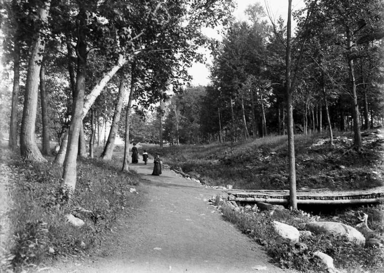
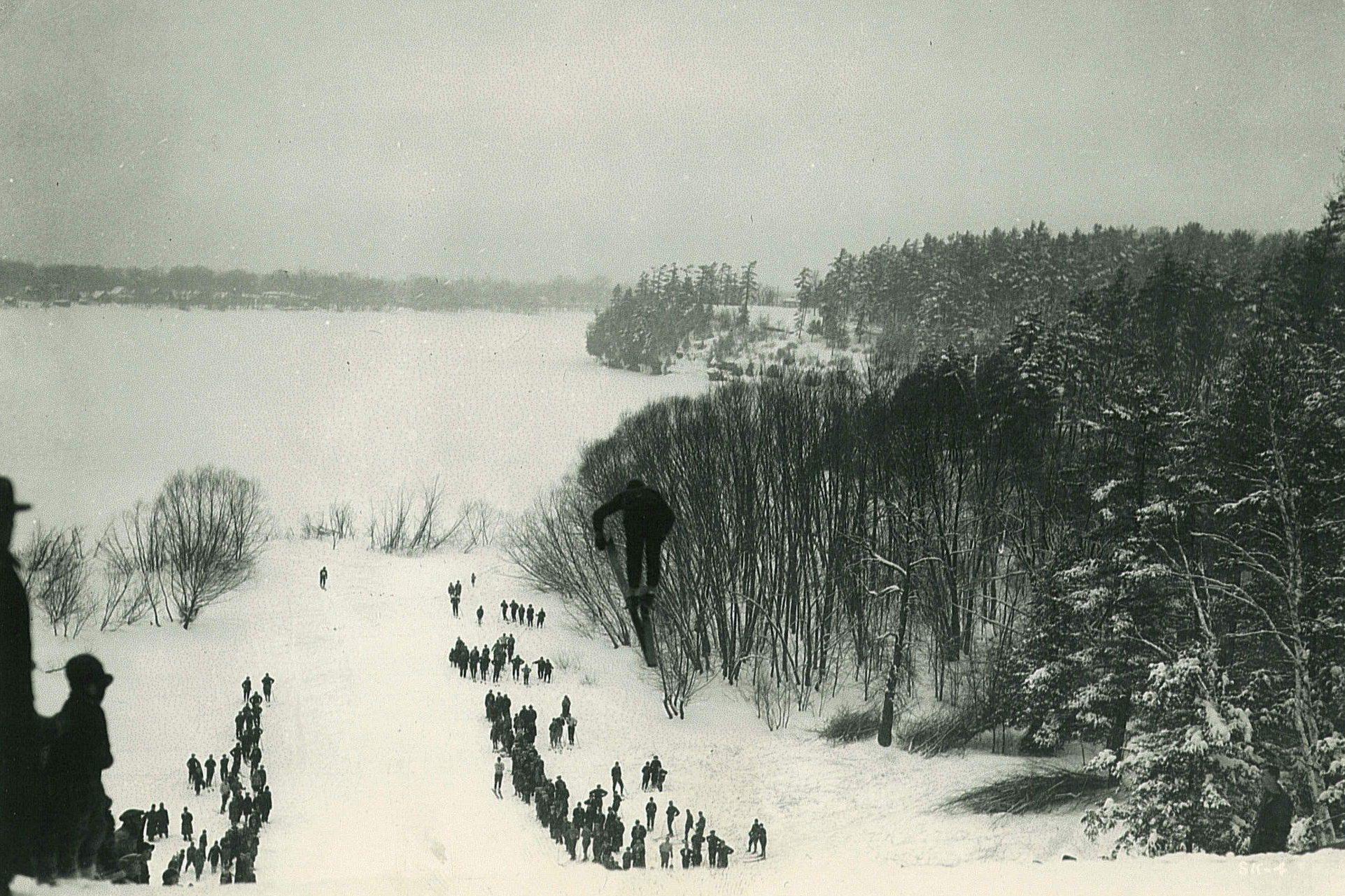
Rockcliffe Park
Leased from the City of Ottawa in 1904, the park was about 32 hectares (80 acres) in size, extending from the grounds of Rideau Hall to the Ottawa River. Parks were a focal point of social activities, and Rockcliffe Park was no exception. In the summer, the park was used for concerts and picnicking, and boats could access the park from various points along the shore. In the winter, skiing was a popular activity and, in 1910, a ski jump was built in the park. Today, the park is still used for social gatherings and activities. While the ski jump is no longer there, you can use this scenic space for a picnic, or rent the pavilion for a wedding ceremony.
Did you know that, by 1915, Rockcliffe Park accounted for over 70 percent of the total park acreage managed by the OIC, and it remained the Commission’s largest park until Gatineau Park was created in the 1940s?

Rideau Canal Driveway
Work on the Rideau Canal Driveway began in July 1900, and was completed in 1905. The Rideau Canal Driveway (now Queen Elizabeth Driveway), was about 6.4 kilometres (four miles) long and ornamented with trees, shrubs and flowers — an improvement from the weed-covered ground that was there before. Work began before a master plan was established and Frederick Todd’s beautification report offered advice on the layout of the Driveway.
Did you know that, near the end of the First World War, only bulbs saved from the previous year were planted? This was a change from early OIC years, when hundreds of thousands of bulbs were planted. This is because there was an uncertainty over shipping, and the excessive cost of bulbs at the beginning of the war.
Another fun fact: there used to be a causeway at Dows Lake. It linked Lakeside Avenue to the corner of Preston Street and the Experimental Farm. The causeway was built in 1904, and its demolition began in late 1928.

Federal District Commission
In 1927, the 60th anniversary of Confederation, the Federal District Commission (FDC) was created, and planning projects in the national capital intensified. It was during the time of the FDC that French architect and urban planner Jacques Gréber was brought in as an advisor. Gréber was a key player in planning the Capital. In 1936, Prime Minister William Lyon Mackenzie King invited Gréber to Ottawa to work on a study for planning the City of Ottawa.
After the war, King’s vision expanded to both sides of the Ottawa River. Jacques Gréber returned to Ottawa and acted as a consultant to the National Capital Planning Committee. He’d indicated “…the work entrusted to me is of national character, and, to make its success sure and rapid, I should like to act as a consultant to a National Capital Planning Committee, working in full cooperation with the Federal District Commission.” These planning committee members, represented by the government of Canada, the government of the provinces of Ontario and Quebec, the cities of Ottawa and Hull and other municipalities within the national capital district, would help shape the future of the Capital. The General Report on the Plan for the National Capital, commonly referred to as the Gréber Plan, was completed in 1950.
Did you know that, in 1934, the FDC was given the responsibility of improving and caring for the grounds of all Dominion government buildings in Ottawa? Canada used to be referred to as the Dominion of Canada. The federal government was referred to as the “Dominion government” until after the Second World War. The term “Dominion” was formally dropped with the 1982 Canada Act.
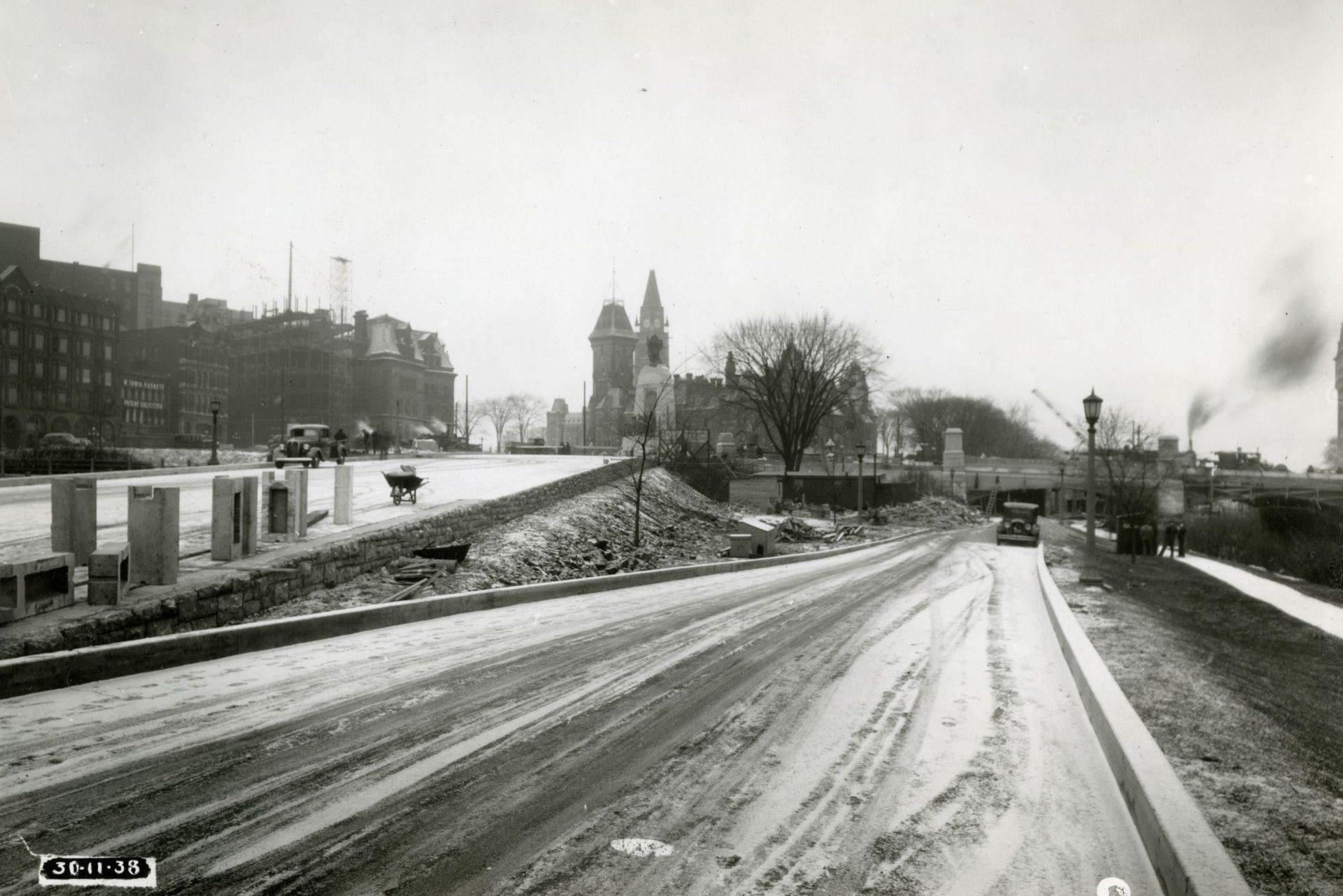
Confederation Square

In 1936, Jacques Gréber had also been asked by Prime Minister King to provide advice on the plans for Confederation Square. Gréber agreed with King on all points, with one exception: the placement of the War Memorial. He believed it would interfere with the traffic flow if it was placed in the centre of Confederation Square.
Between 1937 and 1939, Confederation Square was rebuilt according to Gréber’s drawings and, in 1939, the landscaping of the War Memorial and Confederation Square was completed.
The building of the War Memorial and changing of the traffic layout in that area were highlighted in our blog in November 2018. Other work was also being done on the area during that time, including the widening of the Plaza Bridge.

Beautifying the Capital
Executing the plans of our landscape architects requires a lot of…plants. The OIC first rented and then, in 1912, purchased greenhouses. In 1939, the greenhouses and nurseries in Rockcliffe provided 210,545 plants and flowers to be used in parks and on grounds under the control of the Commission.

A National District
In 1945, an area of 2,330 square kilometres almost equally distributed on both sides of the Ottawa River was declared the National Capital District. The Federal District Commission Act was amended to increase the responsibilities of the FDC, and give it a truly national character. The FDC was a precursor to the National Capital Commission, which would be established in 1959, after Parliament passed the 1958 National Capital Act.

A Donation of Tulips
Princess Juliana of the Netherlands sent the first gift of tulip bulbs to Canada. During the Second World War, the Dutch princess and her family had fled to Canada, where they found refuge and a safe haven. In 1946, the FDC received 20,500 tulip bulbs in appreciation for the kindness that Princess Juliana and her family had received while living in Ottawa.
The NCC is considered to be the official gardener of the Capital, and our landscape architects plan the gardens that you see at the Tulip Festival.

The FDC Winds Down
The last year of operation for the Federal District Commission was 1958. The following are some of the achievements of its final year.
- On June 18, Prime Minister Diefenbaker announced that authority would be granted to the Commission to establish a Greenbelt comprising 37,500 acres around Ottawa. That year, approximately 31,500 acres of privately owned lands were acquired to establish the Greenbelt.
- At the end of 1958, the Commission had purchased 57,000 of the 75,000 acres planned for Gatineau Park. A total of 339,548 people attended Gatineau Park in that year alone.
- Colonel By Drive was the only new driveway construction open to traffic at the time. It was a 3.2-kilometre (two-mile) route along the old Canal Road on the east side of the Rideau Canal between Bronson Avenue and Hog’s Back Falls.
- Seventy-five acres of fully equipped picnic fields at Hog’s Back Falls were opened to the public in the spring.
- Stage one of the railway relocation plan was completed.

The National Capital Commission
The National Capital Act was given royal assent in 1958, creating the National Capital Commission. The National Capital Region was expanded to a total of 4,660 square kilometres of land on both sides of the river, including the northern sector of Gatineau Park and lands designated for the Greenbelt to the south